U.S. Geological Survey
What is PRISM4?
USGS has delivered global boundary conditions and verification data to the climate modeling community (IPCC AR5/PMIP/PlioMIP) enabling eight groups to run parallel AGCM and AOGCM simulations to assess ES Sensitivity, AMOC behavior, role of sea-ice, marine and terrestrial data-model comparisons (DMC's), and causes of past warming for the mid-Pliocene. That work has identified 3 primary areas of discord between simulated and estimated Pliocene paleoclimate conditions. This project will adress each of these through faunal and geochemical analyses coupled with new simulations to be generated in the next phase of PlioMIP. The paleoclimate modeling community requires (1) updated PRISM boundary conditions and (2) new and refined verification data for the next planned simulations as well as a comprehensive analysis of the reasons for disagreement between data and existing simulations. The Pliocene was in many respects similar to the conditions projected for the end of the 21st Century. Enhancing our understanding of Pliocene conditions is fundamental to an overall understanding of future climate.
The PRISM (Pliocene Research, Interpretation and Synoptic Mapping) Project was initially devised to reconstruct surface conditions from a focused stratigraphic interval (3.264 - 3.025 Ma = PRISM interval) that was similar to what we may expect in the near future. A major component of the PRISM reconstruction has been the systematic documentation of the magnitude and variability of Pliocene sea surface temperature (SST) on a global scale. The main purpose of efforts to reconstruct SST and other paleoenvironmental parameters is to provide a conceptual model and synoptic view of the earth during an interval considerably warmer than modern. The acceptance of future global warming has increased interest in documenting and modeling Earth response to past episodes of warming.
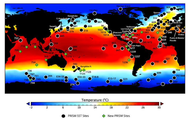
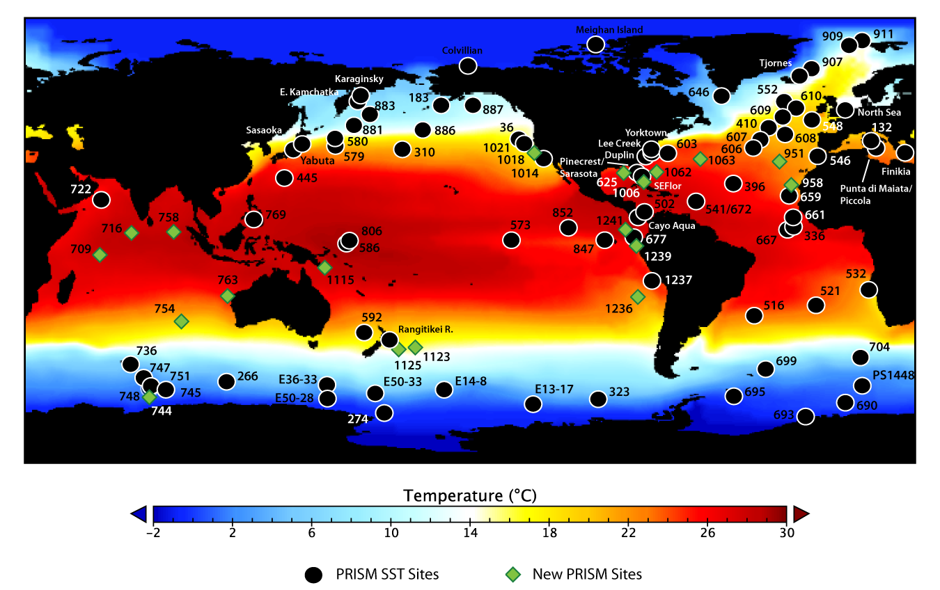
PRISM3 site locations displayed on PRISM3 Mean Annual SST (larger)
PRISM2 evolved from a series of studies that summarized conditions at a large number of marine and terrestrial sites and areas (e.g.. Cronin and Dowsett, 1991; Poore and Sloan, 1996). The first global reconstruction of mid Pliocene climate (PRISM1) was based upon 64 marine and 74 terrestrial sites and included data sets representing annual vegetation and land ice, monthly SST and sea ice, sea level and topography (Dowsett et al., 1996; Thompson and Fleming, 1996). PRISM2 was a revision of PRISM1 incorporating the following significant changes.
Additional marine sites were added to improve coverage. Sites from the Mediterranean and Indian Ocean were incorporated for the first time. All SST estimates were recalculated using a new core-top calibration based upon the Reynolds and Smith (1995) adjusted optimum interpolation (AOI) data set. The Pliocene sea level was re-set at +25m in keeping with isotopic data not available when PRISM1 was released. PRISM2 used model results to guide the areal and topographic distribution of Antarctic ice. This resulted in a much more realistic Antarctic ice configuration in tune with the 25m sea level rise.
A wealth of environmental information is hidden within the PRISM3 paleoclimate reconstruction, and we have a plan to incorporate all valuable climate data into the next generation of PRISM products. Global paleoclimate reconstructions have been invaluable to our understanding of the causes and effects of climate change, but single-temperature representations of the earth’s surface are outdated. The PRISM4 paleoclimate reconstruction will stem the loss of valuable climate information and instead present a holistic and nuanced interpretation of multi-dimensional climate processes and responses.
PRISM3 was the main USGS contribution to a USGS/NSF/NASA collaborative effort. PRISM3 incorporated improvements to the SST and Sea-Ice data as well as increased coverage in the Vegetation data. The SST data has been enhanced by the construction of maximum and minimum probable warming data sets that bracket the range of variability in Pliocene SST. The most significant change was the inclusion of deep-water temperatures and a three-dimensional ocean (PRISM3D). The next generation of fully coupled ocean-atmosphere general circulation models require a 3-D ocean and this is a major improvement to the PRISM data set allowing use in more sophisticated future-climate modeling experiments.
PRISM4 continues with the goal of refining SST reconstructions by producing short high resolution multiple proxy time series centered on time slice instead of a time slab. PRISM4 has a new topography and bathymetry reconstruction and adds soils and lakes to the land cover data. Together with a number of modeling groups (PlioMIP of PMIP2) PRISM4 will explore Pliocene climate as an aid to our understanding of the climate system and future climate conditions. .
|

